
USA Land Surveying Equipment Market Outlook to 2030
Region:United States
Author(s):Shubham Kashyap
Product Code:KROD6315
Region:United States
Author(s):Shubham Kashyap
Product Code:KROD6315
November 2024
95
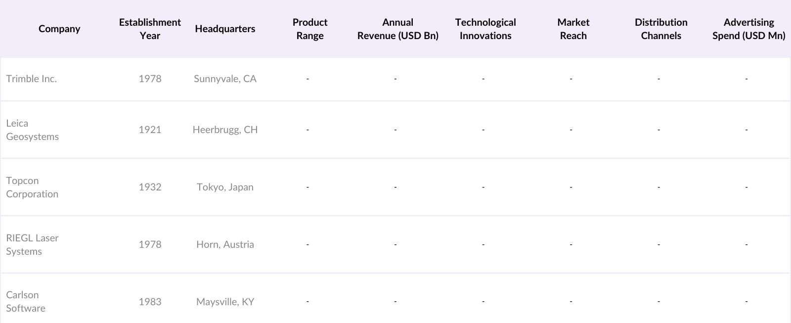
The USA Land Surveying Equipment Market is competitive, with key players such as Trimble Inc., Leica Geosystems, Topcon Corporation, RIEGL Laser Measurement Systems, and Carlson Software leading the market. These companies maintain a strong foothold through continuous technological innovation, comprehensive product portfolios, and robust distribution channels, addressing diverse industry needs.
Growth Drivers
Challenges
The USA Land Surveying Equipment Market is anticipated to exhibit robust growth through 2028, driven by advancements in surveying technologies, an increase in infrastructure projects, and growing urbanization. Government support for accurate land mapping and the integration of digital solutions within the surveying domain are also expected to drive market growth. The future landscape of this market will likely witness continued innovation, especially in drone-based surveying and real-time data integration, creating new opportunities for industry players.
Future Market Opportunities
|
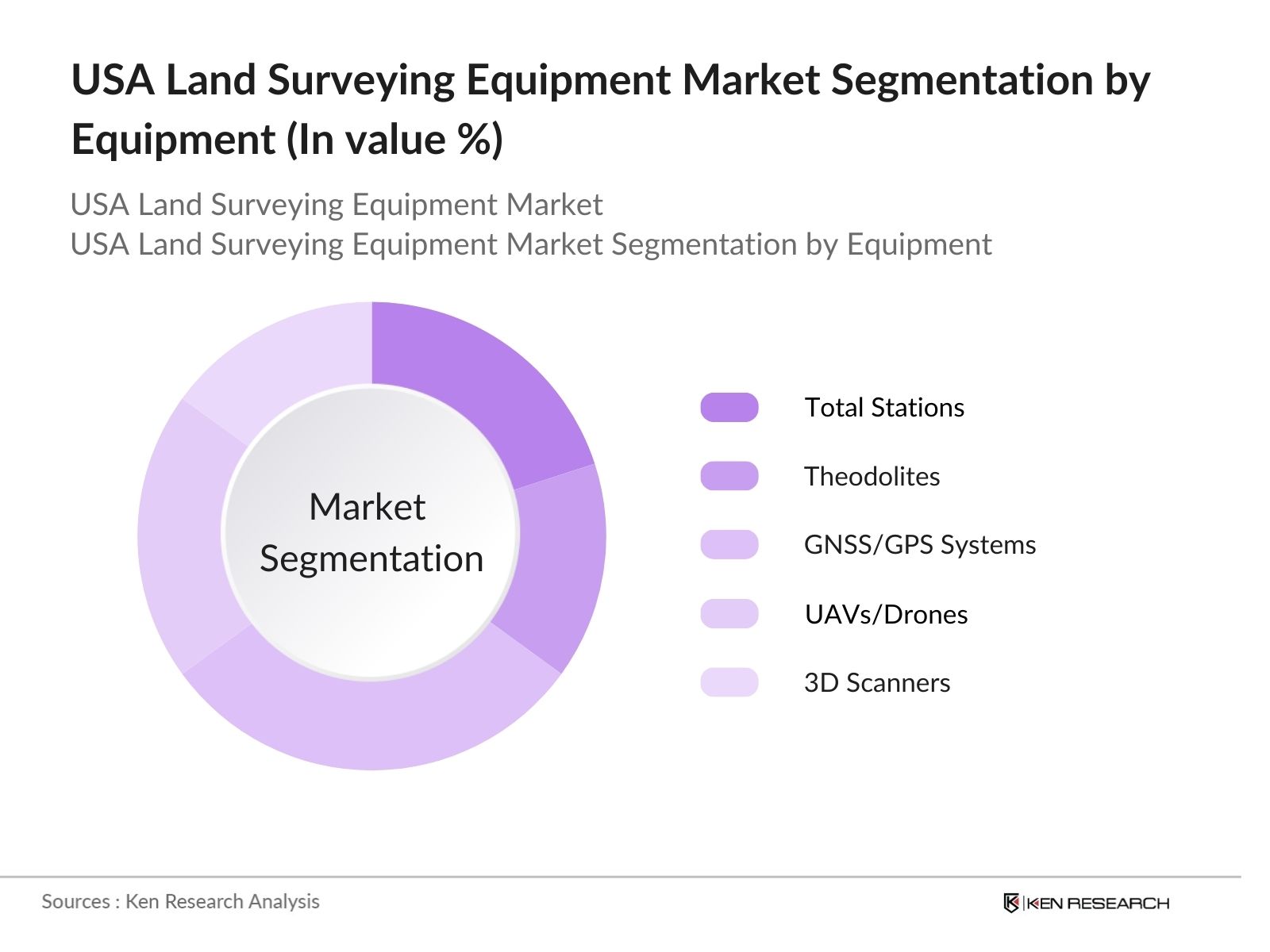
By Equipment Type |
Total Stations Theodolites GNSS/GPS Systems UAVs/Drones, 3D Scanners |
|
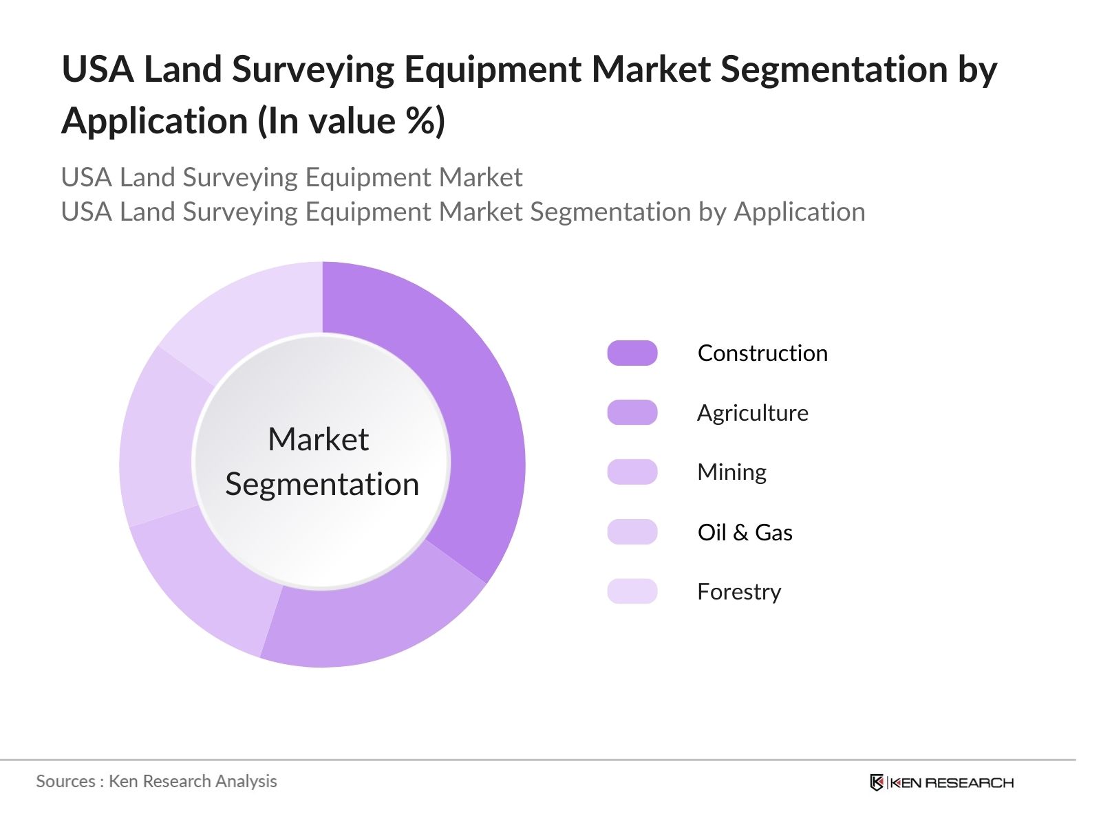
By Application |
Construction Agriculture Mining Oil & Gas Forestry |
|
By Component |
Hardware Software Services |
|
By End-User |
Government Agencies Private Surveying Firms Educational Institutions Utility Providers |
|
By Region |
Northeast Midwest South West |
1.1 Definition and Scope
1.2 Market Taxonomy
1.3 Market Dynamics Overview
1.4 Market Segmentation Overview
2.1 Historical Market Size
2.2 Year-On-Year Growth Analysis
2.3 Major Market Developments
3.1 Market Growth Drivers
3.1.1 Infrastructure Development Projects
3.1.2 Urban Planning Initiatives
3.1.3 Technological Advancements in Surveying Tools
3.1.4 Demand from Construction and Real Estate Sectors
3.2 Market Challenges
3.2.1 High Cost of Surveying Equipment
3.2.2 Skilled Workforce Requirements
3.2.3 Maintenance and Calibration Challenges
3.3 Opportunities
3.3.1 Growing Adoption of Drone Surveying
3.3.2 Expansion of Geographic Information Systems (GIS)
3.3.3 Advancements in 3D Laser Scanning Technology
3.4 Trends
3.4.1 Integration of AI in Surveying Software
3.4.2 Increasing Use of UAVs (Unmanned Aerial Vehicles)
3.4.3 Demand for Portable and User-Friendly Equipment
3.5 Regulatory Impact
3.5.1 Federal and State Land Surveying Standards
3.5.2 Compliance with Geospatial Data Acts
3.5.3 Safety and Environmental Compliance Standards
3.6 SWOT Analysis
3.7 Porters Five Forces Analysis
3.8 Value Chain Analysis
3.9 Stakeholder Ecosystem
4.1 By Equipment Type (in Value %)
4.1.1 Total Stations
4.1.2 Theodolites
4.1.3 GNSS/GPS Systems
4.1.4 UAVs/Drones
4.1.5 3D Scanners
4.2 By Application (in Value %)
4.2.1 Construction
4.2.2 Agriculture
4.2.3 Mining
4.2.4 Oil & Gas
4.2.5 Forestry
4.3 By Component (in Value %)
4.3.1 Hardware
4.3.2 Software
4.3.3 Services
4.4 By End-User (in Value %)
4.4.1 Government Agencies
4.4.2 Private Surveying Firms
4.4.3 Educational Institutions
4.4.4 Utility Providers
4.5 By Region (in Value %)
4.5.1 Northeast
4.5.2 Midwest
4.5.3 South
4.5.4 West
5.1 Detailed Profiles of Major Companies
5.1.1 Trimble Inc.
5.1.2 Leica Geosystems (Hexagon)
5.1.3 Topcon Corporation
5.1.4 Carlson Software
5.1.5 RIEGL Laser Measurement Systems
5.1.6 Sokkia (Topcon Group)
5.1.7 South Surveying & Mapping Technology
5.1.8 CHC Navigation
5.1.9 Spectra Precision
5.1.10 GeoMax Positioning
5.1.11 Hemisphere GNSS
5.1.12 Teledyne Optech
5.1.13 Stonex Srl
5.1.14 Nikon-Trimble
5.1.15 Ashtech (Trimble)
5.2 Cross Comparison Parameters (Headquarters, Product Portfolio, Market Reach, Revenue, Technology Capabilities, Innovation in Products, Partnerships, Customer Base)
5.3 Market Share Analysis
5.4 Strategic Initiatives (Collaborations, Partnerships, and Alliances)
5.5 Key Innovations and Product Launches
5.6 Investment and Funding Analysis
5.7 Acquisitions and Mergers Impact
6.1 Industry Standards and Certifications
6.2 Federal and State Regulations
6.3 Safety and Compliance Norms
7.1 Market Projections
7.2 Key Drivers for Future Growth
8.1 By Equipment Type (in Value %)
8.2 By Application (in Value %)
8.3 By Component (in Value %)
8.4 By End-User (in Value %)
8.5 By Region (in Value %)
8.1 Market Entry Strategies
8.2 Product Differentiation Recommendations
8.3 Regional Market Entry Insights
8.4 Potential Customer Base and Target Market Expansion
Disclaimer Contact Us
This phase entails mapping all stakeholders within the USA Land Surveying Equipment Market, combining secondary research and industry databases to understand influencing factors, regulatory requirements, and technological advancements.
We collect and analyze historical data, focusing on adoption rates and sector-specific demand. This data forms the basis for revenue projections and segmentation trends, ensuring a reliable and structured analysis.
Hypotheses are formulated based on initial findings and validated through interviews with industry experts, who provide insights into operational challenges and growth drivers, confirming the robustness of the data.
The research concludes with extensive consultations with equipment manufacturers to obtain real-time feedback on product demands and market needs, complementing our quantitative data with qualitative insights to ensure a well-rounded report.
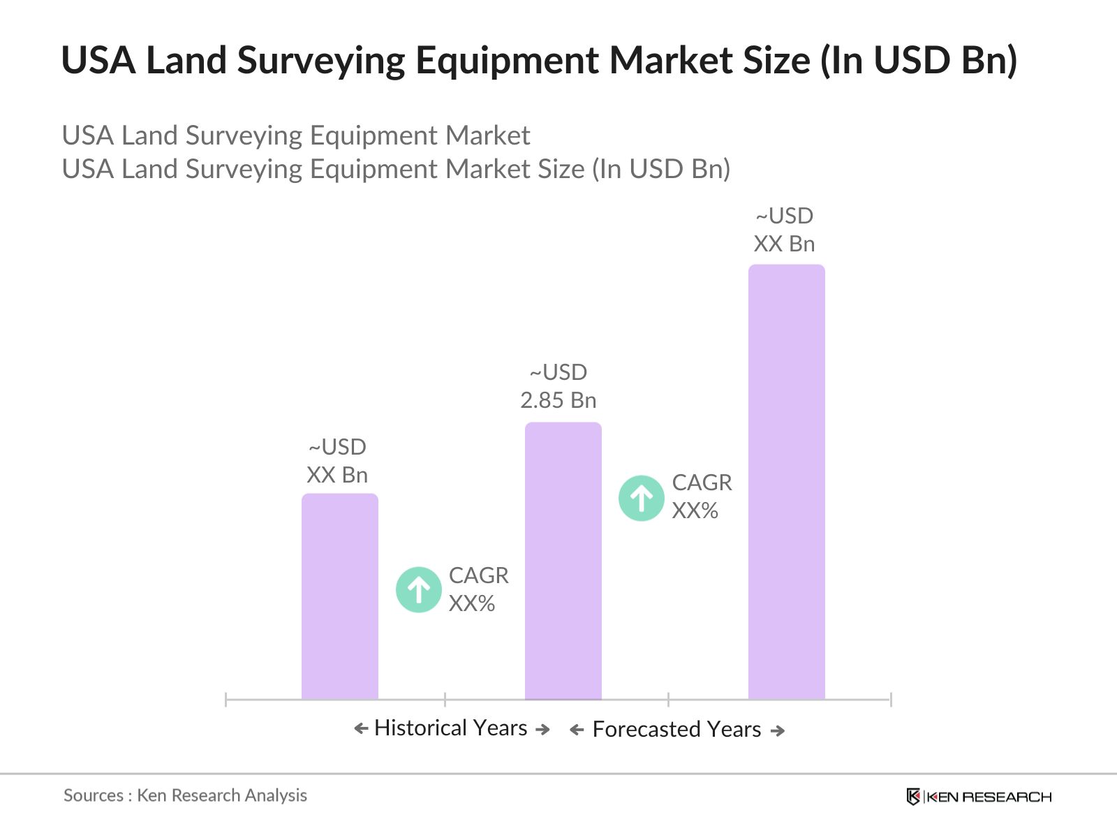
The USA Land Surveying Equipment Market is valued at USD 2.85 billion, driven by infrastructure projects and technological advancements in GNSS and UAV-based surveying solutions.
Challenges in the USA Land Surveying Equipment Market include high costs of equipment, the need for skilled personnel, and technical complexities in maintenance and calibration of advanced surveying tools.
Key players in the USA Land Surveying Equipment Market include Trimble Inc., Leica Geosystems, Topcon Corporation, RIEGL Laser Systems, and Carlson Software, known for their advanced equipment and technology-driven solutions.
The USA Land Surveying Equipment Market is propelled by increasing urbanization, demand for precise land measurement tools, and government support for infrastructure projects, which require high-accuracy surveying equipment.
 Framework")
What makes us stand out is that our consultants follows Robust, Refine and Result (RRR) methodology. i.e. Robust for clear definitions, approaches and sanity checking, Refine for differentiating respondents facts and opinions and Result for presenting data with story

We have set a benchmark in the industry by offering our clients with syndicated and customized market research reports featuring coverage of entire market as well as meticulous research and analyst insights.

While we don't replace traditional research, we flip the method upside down. Our dual approach of Top Bottom & Bottom Top ensures quality deliverable by not just verifying company fundamentals but also looking at the sector and macroeconomic factors.

With one step in the future, our research team constantly tries to show you the bigger picture. We help with some of the tough questions you may encounter along the way: How is the industry positioned? Best marketing channel? KPI's of competitors? By aligning every element, we help maximize success.

Our report gives you instant access to the answers and sources that other companies might choose to hide. We elaborate each steps of research methodology we have used and showcase you the sample size to earn your trust.

If you need any support, we are here! We pride ourselves on universe strength, data quality, and quick, friendly, and professional service.